Author: montescott

Day 13: Winds of Change

September 15, 2002
Deer Lodge to Butte
37 Miles Google Map

Eventually, the elements catch up with you.

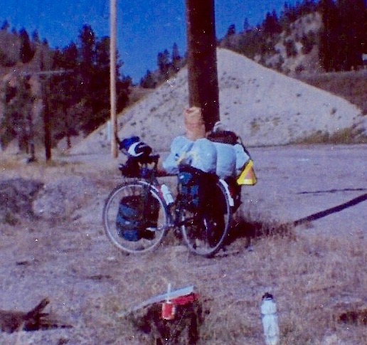
It was supposed to be a short, half-day meander down I-90 to Butte. I was in no hurry to get up and out on the road. Which was a mistake. Just before ten, the morning’s light, almost playful breeze began increasing in strength. It seemed like someone was revving up a giant, invisible fan. Cutting across my path, the gusts gradually became strong enough that at times I struggled to maintain my balance. Things then got worse as the highway inexorably turned southeast, directly into the miniature gale.

It was two and a half hours of frustration leading to exhaustion. All those long stretches of what should be easy, level grade stretching out ahead, and here I am peddling in my lowest gears, hunkered down and barely moving. It was a good thing I did the extra mileage the day before or I’d have had to endure another hour (or more) of punishment.

But all bad things must come to an end. I-90 began to mercifully turn back east, away from the teeth of my tormentor. Soon Butte billboards began sprouting up and I knew the worst was behind me.

Once in town, I elected to check out the budget hotels first. These were mostly located in the “Historic Uptown” of Butte. The first one I stopped at had no one but a large floppy-eared dog manning the office. It being Sunday afternoon, I didn’t necessarily expect anyone to be waiting at the counter. However, the animal got me thinking that perhaps this was not my kind of accommodation. I went further up the street.

Hotel number two looked charming. However, there was broken glass all around the front steps — not a feature to warm the heart of a bike rider. Through the window, I saw a sign saying that there was an extra charge for pets. Not the kind of company I wanted to have around in the middle of the night. Losing what marginal interest I had in the area, I returned to I-90 and shortly came across some modern motels situated around the ubiquitous fast food joints. 

Home again, home again. It’s another Super 8 to spend what will be a couple of nights and since I arrived early in the day, I was rewarded with an agreeable, non-smoking room conveniently located on the first floor (which makes it easier to get the bike in and out of). As I’m coming to find out, not all motel rooms are created equal and this one, with its easy chair and sleek, unscratched furniture, is a step above most others. Perfect for spending my day off tomorrow.

Before hitting the hay, I went outside to do some star gazing and view the famous “Our Lady of the Rockies” statue situated on the Continental Divide east of the city. This likeness of Mother Mary is illuminated by floodlights and looks like an angel suspended in the sky. As for my twinkling friends, I couldn’t see much due to the low clouds, which appeared close enough to touch. (At that point it hit me at I was over a mile above sea level.) It felt like I could almost burst through them and into the darkness beyond.

Distances
    Today:       37 Miles
    To Date:  696 Miles / 1,120 Kilometers

Day 12: A New TV Program

September 14, 2002
Missoula to Deer Lodge
83 Miles Google Map

Hello boys and girls. It’s time once again for your all-time favorite show: Sideswipe The Cyclist.

Brought to you by the Montana Department of Transportation.

As we all know, the U.S. Interstate Highway system usually features two lanes for traffic headed in each direction, plus a generous shoulder. It is this shoulder area where bicycle riders can be found and where drivers must focus their assault. The goal is to swiftly and stealthily approach from the rear (ideally in an SUV or Mac Truck), then abruptly swerve towards the cyclist, forcing him onto the embankment. Points are awarded depending on how far the mark has been forced off the road. A special bonus if the rider falls over.

Kind of like Roller Derby.

To improve the motorists’ chances, the Montana DOT has thoughtfully done the following work on the stretch of I-90 north of Deer Lodge:

— Red cones have been placed in the middle of the road, directing traffic onto the right lane. This squeezes the motorists and cyclists into close proximity, guaranteeing plenty of hair-raising encounters. 

— The shoulder asphalt has been scrapped, leaving a bewildering surface of etched waves and diagonals, not unlike a Picasso painting. These serve the purpose of slowing down and confusing the bicycle riders, making them easier targets. 

So start your engines, and happy hunting!

Despite the above anxieties, it was a well executed, record distance day. In the absence of those traffic-clogging cones, I-90 was actually a very pleasant ride, so much so that I decided to stay on and head towards Butte rather than following the original plan of getting off at the Helena exit. Of course there’s going to be plenty of traffic to contend with on a main thoroughfare, but the shoulder is wide and generally free of pebbles and glass. One can focus exclusively on pedaling. Which I did very well outside of the DOT interruption. 

Although I’m wiped out from it, today’s effort nevertheless put me in a good position. It’s now a short and hopefully not-too-demanding ride into Butte tomorrow where I’ll be taking a day off before going up and over the Continental Divide. 

Today’s accommodations are again courtesy of Super 8 Motels. My long, hot day got me into town a bit later than planned and I ended up with the last single room — a smoking one. I probably could have gotten a better deal elsewhere, but with a McDonalds nearby I lacked the will power to search any further.

Distances
    Today:       83 Miles
    To Date:  659 Miles / 1,061 Kilometers

Day 11: Reaching the Interstate

September 13, 2002
Plains to Missoula
76 Miles Google Map

Technically, I’m about three miles short of Missoula, but this was such a pleasant day of cycling I’m crediting myself with the extra distance.

By the way, it was a very good idea yesterday to pull up and spend the night in Plains. The next town up the road (ironically named Paradise) did not have much of anything; certainly no hotel. I’d have ended up furtively camping out in someone’s back meadow.

This morning I got out of the gate early, a little after seven o’clock. The sun was just coming up, the air was cool and the traffic scarce. There were no steep hills to tackle and plenty of straightaways, allowing me to simply put my head down and pedal. Despite my sore left leg, I pumped out the miles: forty-one by mid-morning.

The hamlet of Dixon turned out to be yet another wide spot, so I had brunch at a restaurant some seven miles further on in Ravalli. Along the way I encountered the first gusts of wind which would bedevil me much of the rest of the day. I also picked up a brief traveling companion in a frisky dog who harmlessly chased me for a few hundred yards.

After finishing my usual eggs and potatoes (and casting nervous glances out the window at the swaying trees), I struggled out of town on a narrow highway then, to my surprise, suddenly put in ten strong miles. The contrary “breezes” had died down; the shoulder of the road got wider; and the food must have kicked in.

Then the wind returned with a vengeance and I found myself struggling up a long hill. But at the top, like a crown jewel, was a Conoco Station and convenience store that provided me with a much-needed Gatorade break. Beyond that gift was an even better one: a downhill slope that seemed to extend for miles. I was able to coast to almost within shouting distance of Interstate 90, my goal for the day. (A second, less pleasant dog took after me partway down and I was fortunate not to be run over when I did a knee-jerk swerve away from the shoulder — and into traffic — to avoid it.)

At this point the Montana Department of Transportation — which would become my travel nemesis — got in the way, tarring the last stretch of road leading to I-90. This closed off one lane, which left me bailing out when trucks inched past on the remaining narrowed one. A few times, after running over one of the tar streaks, I had to stop and scrape off sticky bits of gravel that had adhered to my tires. But eventually I got through the blackness and emerged onto the wide and forgiving Interstate. For the next six miles, I cruised and watched Missoula unfold around me.

My Motel 6 (how I love motels with numbers in their names) is as far removed from last night’s depressing dump as the Earth is from the moon. The furniture is newer and more comfortable, and the desk doesn’t look like it’s about to collapse. There is even a laundry facility that allowed me to skip the washing-by-hand ritual for tonight.

Dinner was a couple of McDonald’s burgers and a vanilla shake mixed with Cherry Pepsi. It all tasted near heavenly, I’m embarrassed to admit.

Distances
    Today:       76 Miles
    To Date:  576 Miles / 927 Kilometers

Day 10: The Heat Goes On

September 12, 2002
Near Noxon to Plains
71 Miles Google Map

This day started out pleasantly enough. I’d gotten in a full morning of cycling and had had the “Maidrite Special” for lunch in the Thompson Falls Boomtown Cafe. Feeling pretty good with no body complaints (for a change). The score was thirty-five miles done, maybe thirty-two to go. But what’s that number up on the bank display? Yes, it’s eighty-four. As in degrees. As in “You’ve got a tough, hot ride coming up”.

Leaving Thompson Falls, the heat hit me immediately. Worse, there was really no roadside shade to pull over and hide under for temporary relief. Just the occasional group of straggling pines or junipers in the distance which looked to be in worse shape than I.

Then there was another map mystery: a phantom rest area supposedly located somewhere between Thompson Falls and Plains. Spent the entire afternoon on the lookout for a picnic table, or least a place I could stop and comfortably stretch my legs, but it was all in vain.

Towards Plains, the road had recently been asphalted in stylish black. It already felt like I’d been cycling under a heat lamp; now there was a skillet underneath. If I fell off the bike, I’d sprawl on the road and fry like an egg.

I pushed on. Fortunately there were no large hills to climb or headwinds to contend with. Just the heat. Off to the right were occasional glimpses of the refreshing and inviting Clark Fork River. I made up my mind that in the event some semi truck accidentally came too close while we were crossing a bridge, to avoid a collision I’d deliberately go over the edge and into the water. It would almost be worth a broken leg to be immersed in its coolness.

Entering Plains was confusing. There’s a real estate office, a couple more businesses, then suddenly you find yourself out in the country again. It was only the advertisement of a malt and burger place further on that made me realize civilization had not entirely abandoned me.

After a cherry malt and maybe a gallon of cold water, I decided to call it quits some seven miles short of my original destination. Stepping out of the restaurant was like entering an oven. Following some directions I’d received, I cycled through the remainder of the town and found a run-down motel on the outskirts. Aside from a short food run, I’ve since been lying on the bed, semi-comatose. Even going to the bathroom requires an inordinate amount of energy.

In the same manner as Icarus, I’ve cycled too close to the sun.

Will hit the trail again tomorrow.

Distances
    Today:       71 Miles
    To Date:  500 Miles / 804 Kilometers

Roadside Break

Day 9: Catching a Break

September 11, 2002
Priest River, ID to Near Noxon, MT
60 Miles Google Map

My knees were sore and my stomach was complaining from last night’s spicy taco salad…what a fragile body I have. The auspicious beginning meant another “slog day” was at hand.

My mood temporarily brightened once I made the turn at Sand Point and later headed south. I guess it was the symbolism of having reached the northernmost point of the ride combined with the stunning beauty of the Idaho panhandle. But the ironically named towns of Hope and East Hope did not have restaurants near the highway, and I wasn’t in the mood to climb any of the hills in search of lunch. So I cycled on and ended up eating at Clark Fork. 

After that, things got a bit weird.

I crossed the state line into Montana, planning to stay at a place called Heron. According to the f*cking map, it was just off the main road.

Yeah, right. I turned off the highway in accordance with a sign I’d passed only to find myself aimlessly cycling over meadows and through woods with no hint of a town. (Or, for that matter, grandma’s house.) Soon, after crossing a narrow, patched bridge, I decided there was little chance of coming across any place to spend the night and turned around, having wasted over a half hour’s worth of valuable energy. 

To the best of my knowledge Heron, like Area 51, may or may not exist.

This little misadventure put me in a bad spot. The next town shown on the map (Noxon) appeared too small to offer anything in the way of accommodations — assuming of course that it was even there. Still, I had to stay somewhere so I began mentally preparing myself for a final, dramatic eighteen mile push. Strangely enough, my left leg, which had been complaining off an on most of the afternoon, completely stopped aching. Perhaps my new resolve had made it decide there was little chance of getting my attention.

Then, just as the day’s heat seemed to peak, my luck turned around. The fellow at a grocery place I stopped at informed me there was a small hotel a mere four miles down the road. Out in the middle of nowhere.

I was saved!

It turned out to be a plain, four unit building connected to an Exxon service station, but to me it appeared almost majestic. The price was also reasonable, though in my near-hysterical relief I would have paid almost anything they asked. 

I’m now doing my writing sitting outside my room as evening falls. With its quiet isolation, hemmed in by steep hills topped with evergreens, this place is a lovely getaway. It’s almost spooky how easily silence comes to these parts. Perhaps because they are not yet completely tamed.

A bit later…
While drawing my bath (which sounds vaguely aristocratic), I watched through the window as the nearly first quarter moon set behind the hills. I then used my newfound serenity to casually swat about a dozen pesky mosquitos that had gotten in and were buzzing about the bed light.

Distances
    Today:       60 Miles
    To Date:  429 Miles / 690 Kilometers

Day 8: Across the Panhandle

September 10, 2002  
Spokane, WA to Priest River, ID  
48 Miles Google Map

Today was one of those occasions where, under more pleasant circumstances, I could have possibly pushed myself to another seventy mile effort. But I was doing good this morning simply to get up and out on the road.

It was a miserable night. The mattress was too soft and around 4:00 a.m. I awoke with a backache, a sore neck and the remnants of that migraine. I fixed the discomfort by putting my blue sleeping pad beneath me, which added some firmness. But it was nowhere near a quality night’s rest. In my muddled state, I at one point was considering extending my stay at the hotel in hopes that by some miracle I’d get better shuteye the second time around. But I came to my senses and managed to get myself up, packed, and out the door. After about a half hour of peddling, I began feeling better although it became unpleasantly hot after lunch. I had to stop and replenish my water bottles a couple of times.

I’m now in a far better hotel (in Idaho!) with only a trace of the migraine. Considering the heat and my general condition, I’m going to chalk this day up as a minor victory. There are going to be times where I’ll have little enthusiasm for arising in the early morning chilliness in order to cycle for six or more hours. But there’s really no other choice. I run the risk of increasingly unpleasant weather if this little expedition runs past the middle of next month. In a very real sense, I am racing the season. And grandma’s birthday also will not wait!

Later…
Instead of munching on some tasteless convenience store sandwich-and-chips dinner in my hotel room, I instead went out to a Mexican restaurant recommended by the woman at the front desk. There I enjoyed the best taco salad of the year and passed on my compliments to the cook. (Of course, I was so famished they could have substituted Alpo for the beef and I would not have noticed.)

Besides the food, I liked the friendliness of the place. Everyone seemed to know everyone else. A welcomed contrast to the anonymity of the big city.

For the evening’s entertainment, I caught not one but two good movies on cable — but should have gone to bed after the first. The weatherman is saying tomorrow is going to be another hot one.

Distances
    Today:       48 Miles
    To Date:  369 Miles / 594 Kilometers

IDLake

Day 7: And Then I Rested

September 9, 2002
Spokane Day Off
No Miles  No Map

My first vacation of this trip!

Spent the morning stocking up on needed supplies such as vitamins, skin moisturizer, and that weird green paper which fits so well into my wallet, then mysteriously disappears. After that I found a nearby spacious park to take in the perfect September weather.

My brother’s eldest step-daughter — or maybe I should say my step-niece? — drove to my hotel and took me out to lunch at a semi-fancy Japanese restaurant. Her name is Jessica and she is in her early twenties. It was one of those slightly nervous, getting-to-know-you meetings that was helped by a stroll in what was my second park of the day. We had a pleasant enough time; it was nice having someone to talk to after six largely wordless days cycling across the state. Afterwards, I got in a visit to my neighborhood Dairy Queen, then had a long-anticipated nap. (I’d fallen behind on my sack time and needed to catchup.)

When I awoke (to a surprise call from the parents), my old adversary, Mr Migraine, had settled in for a visit. It takes a combination of at least two triggers (out of the four or five I know of) to cause an occurrence. One is accumulated stress, something I’ve had in abundance this past week. Yes, I’m having possibly the experience of a lifetime, but it has been replete with grueling challenges. Another likely culprit is my lazy diet — those D.Q. hamburgers are probably not the ideal food for cross-country cycling.

In any event, the more severe migraines can last almost twenty four hours due to the long fade-out. I can function throughout it all, but at the height of the throbbing (usually somewhere in the middle of the grand event) have precious little ambition for anything even remotely strenuous. All I can do is take something with ibuprofen (such as Advil) to try and soften the blow. Rarely do I knock it out completely. Such was the case here.

I found myself feeling a bit depressed later in the afternoon. Besides the monster headache, the hotel was definitely on the crummy side, plus the next day I had to go “back to work”.

Distances
    Today:     None — Rest Day. 
    To Date:  321 Miles / 517 Kilometers

Day 6: Pushing On Ahead

September 8, 2002
Wilbur to Spokane
70 Miles Google Map

This was one of those shut-up-and-cycle days. It started off by my going a mile in the wrong direction. After leaving the hotel in Wilbur, I messed up the first turn of the day by going right instead of left and didn’t notice my mistake until I was halfway out of town. This did not put me in the best of moods. But after a few choice expletives I calmed myself down, backtracked and eventually was out amongst the rolling hills to the east, each one a bit higher than the last. After a half hour of vigorous climbing, I could still look back and see Wilbur in the distance. Discouraging. But perhaps this was divine punishment for my misguided beginning.

To add to this purgatory, a relentless south wind blew across my path the entire morning. As the road turned to the southeast, it became a kind of diagonal drag on my progress. I soldiered on, knowing that mentally I wasn’t at my best. I even got careless with my eating, neglecting lunch until after 1:00 p.m. and almost falling asleep during the meal. My body’s way of telling me I was pushing the proverbial envelope. 

I reached Spokane by late afternoon. An unexpected benefit entering the city was the long downhill road leading from the airport into downtown. The biking challenges soon shifted from tackling rolling terrain and battling stubborn winds to traffic navigation while keeping an eye out for broken glass on the pavement.

The central part of the town held no fascination for me, so I headed north on good old State Highway #2 that I’d been following the last two days out of Orondo. Four miles later, after passing numerous malls, restaurants and car dealerships, I hit the cheap hotel zone. The place I chose to crash at is just across the highway from the “new and improved” K-Mart. My eating out options include an Arby’s, an A & W and a Taco Bell.

American Culture: Love it or eat it.

After almost a week on the road, it was time to do some obligatory calls to the family. It turns out one of my brother’s step-daughters lives here in Spokane with her father. She and I are going to meet for lunch tomorrow, which will be an R & R day for me.

Distances
    Today:       70 Miles
    To Date:  321 Miles / 517 Kilometers

Day 5: Dusty Hamlets

September 7, 2002 
Waterville to Wilbur
71 Miles Google Map

A day where I extended big time. The original plan was to go forty miles to a place called Coulee City south of the great dam on the Columbia River. But after arriving there, and enjoying a hamburger and chocolate shake lunch at a run-of-the-mill eatery, I found I still had plenty of gas in the tank, so I added a solid afternoon of cycling that has placed me within a day’s ride of good old Spokaloo (Spokane). 

My ambition knowing no bounds, I even managed to tackle the laundry after locating a hotel in what is another dry, Eastern Washington village. The manager was thoughtful enough to provide the detergent. Can’t beat hospitality!

Hard to believe I went so far on what is still the first week of my journey.

Distances
    Today:       71 Miles
    To Date:  251 Miles / 404 Kilometers

Day 4: Hell Canyon

September 6, 2002
Lake Wenatchee State Park to Waterville
66 Miles Google Map

Started off the day wearing the ski gloves I’d brought along to keep my hands warm on chilly mornings. By mid-afternoon I was applying suntan lotion. Late afternoon had me checking into a graceful century-old hotel in a lonely high plains town, just ahead of a rain squall.

If the goal of this trip was variety, then I can stop right now. 

It took almost an hour and a half to pack up camp this morning. Not sure why. Folding a small tent and its cover isn’t exactly rocket science. Good thing there was a restaurant not far down the road as I was running late. For the second day in a row I had a full breakfast, but this time it wasn’t smothered in potatoes. While shoveling in the food, I was treated to John Lennon’s “Jealous Guy”. Nice to know the (ex) Beatles are still with me.

The first stage of the ride was a long and winding downhill coast as I descended the east slopes of the Cascades into the Bavarian community of Leavenworth. Plenty of tourists ambling about, which gave the town somewhat of a festive air which I took in while relaxing for awhile in a park. Riding out of Leavenworth, the road straightened and leveled off and I got into a nice cycling groove. I resumed this after lunch in Lincoln Rock State Park as I turned north, following the Columbia River up to Orondo. At that point, I was only some eight miles from my destination for the day. What could possibly go wrong?

If there is a cycling hell, it must surely include the stretch of Highway 2 east of Orondo: over five miles of constant five to six degree inclines as the road tortuously climbs up through a canyon. Worse yet, the inclines had countless false endings. I’d pedal up towards the end of a long curve expecting to be near the top only to encounter a new stretch of ascending punishment.

I knew I should have gone to church last Sunday.

If given the choice, I’d rather do Steven’s Pass a second time instead of today’s death ride. The highway to the pass is a bit steeper, but at least it doesn’t tease you. By contrast, there were times during today’s relentless grind when I swore I could hear the asphalt chuckling.

Reaching the long-anticipated top, I felt I was in some kind of reverse “Wizard of Oz” scenario. What greenery there was had been gradually disappearing the entire day, leaving me in what looked like Kansas. All around were plowed brown fields with occasional patches of yellowed wheat. Soon thereafter I caught sight of my destination: the rustic community of Waterville, which is the highest incorporated town in the state of Washington — a fact I could have easily gone without knowing.

I counted myself very lucky that the village had a hotel. Given its size and remote location, it’s a wonder there’s even a grocery store.

The hotel owner, who’s up to his elbows doing restoration work on the place, gave me a cozy, tiny room and helped store my bike. I feel like I’ve gone back in time here — the guy has done a superb job of re-capturing the past. The bedrooms, for example, have no TV, just restored antique radios dating from sixty to seventy years ago (according to the owner). And while I have a sink in my room, the toilet is down the hall, past old photographs and other snug bedrooms, which make the atmosphere more intimate and welcoming. Almost like staying in someone’s house. It helps a person understand how people got by in the old days without all the snazzy accommodations hotels now offer. 

Time for one more trip to the ancient bathroom of yesteryear. If I run into anyone, I may ask what they think of President Roosevelt and whether we should stay out of that European war which is brewing. Then, I shall sleep for the rest of the month.

Postscript: Just prior to hitting the hay, I tried the old-fashioned radio and instead of hearing Glenn Miller, was treated to Paul McCartney’s “Jet”. Now there’s a song that would have had a 1920s wheat buyer, passing through on his way to Spokane, probably covering his ears!

Distances
    Today:       66 Miles
    To Date:  180 Miles / 290 Kilometers

WALakeWenanchi
Breakfast By The Lake